
 English
  Español
 - Details
- Written by Administrator
- Category: Uncategorised
- Hits: 2759
Putre is ideal as a starting point for hikes. The routes have been used for centuries by the Aymara farmers and you might encounter them even today on the road leading their lama herds. The diversity of cactus and bird species satisfys every nature lover's heart. Following itineraries are easy to hike without a local guide using the descriptions below..
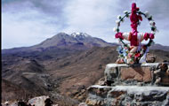
ROUND TRIP PITACANE
This circular hike leads through beautiful gorges up to a pre-hispanic settlement, the petroglyphs of Wilakahuranny and the summit cross of Pitacane. The Pitacane offers a beautiful panoramic view over the surrounding valleys and canyons, the Nevados de Putre and the village of Putre up to the Lluta Valley.
Duration: 1 day
Severity: Normal
Hiking area: Chile / Putre
- Details
- Written by Administrator
- Category: Uncategorised
- Hits: 2589
PARINACOTA VOLCANO (6,350 M)
Duration:2 days
Level of difficulty:schwer
Region:Chile / Putre
Starting point:La Chakana
Download:GPS-Data
ARRIVAL
Southbound:
From Putre take the tarmac road up to the ranger station in Lauca National Park at Lake Chungará (69 km). Ask here the park ranger for the hiking path leading to the feet of Parinacota. The first 1.5 km lead you back on the tarmac road up to the pump house at the lake. At the junction turn right. The path leads now for 9 km towards the volcano taking you through many confusing junctions. During high season the easiest way to stay on the right track is to follow the path with the highest number of car tracks. We have easily recognized even the starting point for the ascent by the signs of a beaten trail.
Northbound:
In Putre there are various tour operators which can organize your transport to Caquena and then further up to the base camp of the northern route. The local military forces can also help you reach the base camp (the mountain regiment Huamachuco), however the necessary arrangements must be organized a long time in advance. In order to reach Caquena you take the international pass road starting in Putre and follow it up to Parinacota. From here you drive another hour on a dirt road up to Cauquena, located at 4,401 m altitude. It is advisable to spend here a couple of days in order get used to the high altitude. 500 meters before Cauquena an offroad track splits up and leads towards the volcano drive passing Bofedales (wet grasslands). After having crossed a sandy section of the road you reach an intersection where you turn left. The base camp is located behind the hill ahead at 4,823 m.
DESCRIPTION
Southbound:
From here - at 4,600 m altitude - it is a very long ascent to the summit. It helps to walk another 2-3 hours on the first day already. However, just below the snow line there are very few flat areas suitable for setting up a camp. Depending on the snow situation the entire ration of drinking water might have to be carried along (5 liters per person per day). The road is strongly frequented in the high season and marked by rock cairns. It leads first towards East for a long time up to a drawn-out ridge. At the upper end of the ridge, at 5,100 m, you find the last camping place. The next day you continue the ascent using crampons and ice pick following the route. For the way up to the peak and back to the camp used the day before you need up to 12 hours.
Northbound:
Ascent from the base camp to the camp "Huisquitistay" (591 m, 3-4 hours with heavy equipment). A sandy path leads on the rocky hillside up to a large plateau. From there you see to the left a rubble slope and to the right a small rift. Cross the rift and walk further up to 5,272 m. Once you reach this point continues up to the small plateau "Huisquitistay" at 5,414 m where you set up the camp. It is advisable to spend here one full day in order to get acclimatized to the altitude and to study the ascent in front of you. If the climb takes place at a point in time with no snow around you must bring along all drinking water needed for the entire tour. Should you find melting water collect it from as closed as possible to snow fields. Due to the volcanic origin of the rocks it often creates stomach diseases. Campo Alto Huisquitistay - Cumbre - Campo Alto, (941 m 6-9 hours and 3-4 hrs).
IMPORTANT NOTES
The summit day mainly depends on the snow conditions. Penitent snow can easily be up to one meter deep. Walking through this kind of penitent snow is not only very strenuous, it can also become very time consuming. We recommend to climb the summit early in the morning. Climb first the peak in front of the main peak, from here the final destination can already be seen. During the ascent you should keep to the left since on the right side there are several dangerous crevices. For the climb ice pick and crampons are necessary.
- Details
- Written by Administrator
- Category: Uncategorised
- Hits: 2492
HIKE TO THE ROCK PAINTINGS OF WILAKAHURANNY
Duration:1/2 day
Level of difficulty:Normal
Region:Chile / Putre
Starting point:La ChakanaDownload:GPS-Data
ARRIVAL
The hike starts at Chakana in Putre. Arrival
DESCRIPTION
You cross the whole city of Putre, walk past the Plaza with its old church and take the path which leads downwards from the school and the military compound to the West. You leave more and more populated area behind you. To the left and to the right only some grazing areas are to be seen. Next you follow the path towards Puquios which is lined with two old stone walls.
After about 3.9 km the path splits in both directions, up and down. Here we take the north-western side of the valley downhill. We walk a narrow path which leads along tall cliffs and let us gaze into deep canyons covered by meadow foxtail. To the right a veritable cacti paradise opens up. 4.5 km further we discover an old shepherd hut. Now and then we see traditional terraces which are cultivate even on the steepest slopes.
After another 5.8 km you discover high up a lovely viewing point and camp from where you have a magnificent view over a pre-hispanic settlement which cannot be seen from down below. After another 200 meters the Wiakahuranny rock paintings appear - red on white bedrock. From here the same path leads us back to Putre constantly bringing new views and view points over the city.
IMPORTANT NOTES
Think of drinking water and sunscreen
Page 3 of 5
- You are here:
-
Home

- Uncategorised


